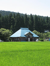
From Tsugawa Station we headed almost due south, following national route 49 until we came to prefectural route 227, which would eventually become the Honna-Tsugawa Forest Road. The 1,300 meter peaks of the Echigo Range, which we would have to cross later in the day, were visible only as markings on our maps, for the fog in Tsugawa obliterated all but the nearest objects. After a few kilometers on Rt. 227, we entered Kamikawa Village, and for the next two hours we rode along the Muroya River, past scattered farmhouses, the brown stubble of small rice fields recently harvested, and at one point the lovely wooden classroom building of a defunct elementary school, sad, silent testimony to the slow but inexorable death of rural communities such as Kamikawa. We had the road practically to ourselves, and as the gradient was gentle, it was a most pleasant start to this leg of the journey. A gradual lightening of the atmosphere heralded the lifting of the fog, and by mid-morning we were treated to spectacular views around every road-bend.
Wednesday, October 31, 2007
Thursday, October 25, 2007
Onward through the Fog
Though a glorious day was breaking as we departed Niitsu, we soon entered a twilight region where everthing save the train itself, the Agano River (whose course the line followed), and the bases of the nearest mountains, was enshrouded in fog, and not a ray of sun penetrated. There was a sense of eeriness and mystery, as though we had entered a world as yet undiscovered. There was also a mundane concern that the fog would turn to rain. An hour or so after pulling out of Niitsu Station, the train pulled into Tsugawa, and we got off.
Friday, October 19, 2007
The First Leg
Tsugawa, formerly a town in its own right but now part of the larger entity Aga City, lies along the banks of the Agano River some 60k east of Niigata City. The first train to Aizu Wakamatsu, with service to Tsugawa, departs not from Niigata but from Niitsu, 25k distant in the direction of Tsugawa. It leaves Niitsu at an unseasonably early 6:06A.M. Don and I knew a long day awaited us (though just how long we never imagined), so we grudgingly agreed to forgo several hours of Sunday slumber to cycle to Niitsu in time to catch the 6:06.
Monday, October 15, 2007
越後 山脈 The Echigo Mountain Range
If one is fortunate enough to possess a map showing it, the Honna-Tsugawa Forest Road appears as the faintest of cartographic lines. On the Niigata side it begins where Rt. 227 ends; thence it heads directly for the wall of peaks forming the Echigo Mountain Range, which comprises the boundary between Niigata and Fukushima prefectures. Snaking its way up Mujinagamori (Badger Forest) Mountain (1315m) and traversing the 1,130m Shionoso (Salt Warehouse) Pass, the track then seems to free-fall into the lap of Honna, a village on the Fukushima side. Was the road passable? Would our bikes, Kona Smokes designed primarily for road use, prove sturdy enough for the rough conditions we would likely encounter? Intrigued rather than deterred, we planned our excursion for Sunday, Oct. 14, and consulted JR's timetables for the earliest train to Tsugawa.
Introductory
Subscribe to:
Posts (Atom)